What is Ground Penetrating Radar (GPR)
Ground Penetrating Radar (GPR) is a tool that helps us “search” underground without digging. It can detect pipes, cables, voids, concrete thickness, or other objects under the surface. This makes it very useful for inspection and maintenance, especially for roads, sidewalks, and underground utilities.
At EJEC Thailand, in partnership with Canaan Geo Research, we use GPR as part of our inspection & maintenance services. GPR helps us check underground conditions for preventive maintenance and repair planning more safely and efficiently.
- What is Ground Penetrating Radar (GPR)
- How GPR helps road maintenance
- Efficiency in Motion: The GMS3 3D Mobile Mapping System
- Common Questions About GPR Surveys
What is Ground Penetrating Radar (GPR)
Ground Penetrating Radar (GPR) is a high-precision, non-destructive testing (NDT) method used to visualize subsurface structures. By transmitting high-frequency electromagnetic radio waves into the ground, GPR detects reflections from underground objects like utility pipes, cables, and—most critically—subsurface voids. At EJEC Thailand, we utilize this technology to provide safe, efficient inspections that prevent infrastructure failure without the need for costly and disruptive excavation.
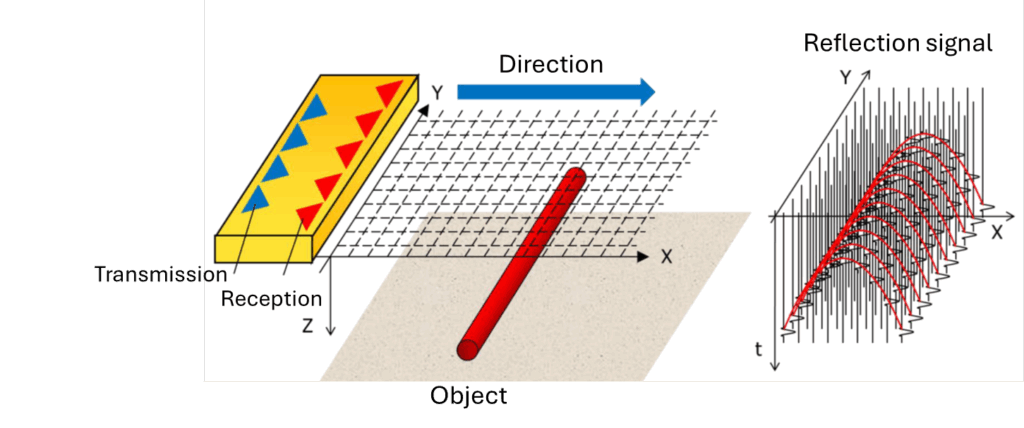
How Ground Penetrating Radar works
GPR works by sending high-frequency radio waves into the ground. When these waves hit something with a different material (like metal, pipes, water, or void), they reflect back. The GPR receiver records these reflections, creating a map of what’s below the surface.
How GPR helps road maintenance
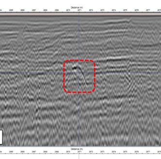
- Detects cavities and sinkholes early: GPR can find hidden voids, weak spots, or underground cavities under roads before they become dangerous.
- Prevents accidents: By spotting potential road collapses or sinkholes early, it helps protect drivers and pedestrians.
- Saves repair costs: Early detection means small problems can be fixed before they turn into expensive repairs.
- Supports preventive maintenance: Helps engineers plan road repairs more effectively, keeping roads safe and durable.
Efficiency in Motion: The GMS3 3D Mobile Mapping System
For large-scale road inspections, traditional handheld GPR is often too slow. We use the Ground-penetrating radar Mobile Mapping System 3D (GMS3). This system revolutionizes the survey process through a three-step workflow:
- Synchronized Data Capture: Our survey vehicle drives at normal traffic speeds, using 360-degree cameras and 3D GPR sensors to map the surface and subsurface simultaneously.
- Unified 3D Analysis: By overlaying terrestrial images with underground radar data, we create a "transparent" view of the road.
- Risk Level Assessment: Every detected anomaly is categorized by size and depth, allowing municipal authorities to prioritize urgent repairs.
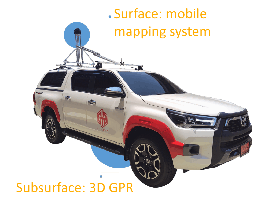
By integrating surface data (Mobile Mapping System) and subsurface data (3D GPR), we can visualize and use information more easily. This helps us plan future road maintenance better and cover more problem areas.
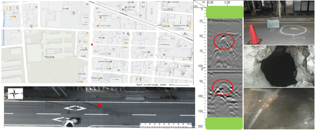
From the image above, we can accurately locate the position of the voids, showing the location on Google Maps, the road surface image, and the GPR signal image.
Common Questions About GPR Surveys
Q: How deep can GPR penetrate the ground?
A: The penetration depth of GPR depends on soil conditions and moisture levels. In the specific environment of Bangkok, GPR typically reaches depths of 1.5 to 3 meters. This depth is ideal for detecting subsurface voids, utility pipes, and potential sinkholes beneath road surfaces.
Q: How long does a GPR survey take?
A: With GMS3 system, we can survey several kilometers of road per day. Unlike traditional manual GPR methods, our vehicle-mounted technology allows us to collect high-resolution data at normal traffic speeds, ensuring no disruption to public transit or road users.
Read more on Thailand’s First Standard for Detecting Underground Road Cavities Introduced by KMUTT and Ehime University
For more information, please visit:
https://ejec-thailand.com/maintenance/inspection-tools/
https://canaan-geo.jp/